![]()


WATERSHED MODELING FOR DISASTER RESPONSE:
Research Group: Jiabao Guan and Mustafa M. Aral
In this case, although it is related, WMD does not stand for Weapons for Mass Destruction. In this case WMD-R stands for Watershed Modeling for Disaster Response.
Watershed Modeling for Disaster Response (WMD-R) is a Geographic Information Systems (GIS) based computational platform through which users will be able to study migration of contaminants at a watershed scale. The computational platform uses standard GIS environment with the models necessary to simulate the contaminant fate and transport processes running on a Visual BasicTM environment at the backgr
ound. The computational steps can be activated through a menu-button control environment similar to other options of the GIS system (Figure on the right).
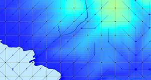
The computational platform makes use of the standard digital elevation raster images to extract the elevations and land cover raster maps to extract the land cover information. This database is automatically transferred to the mesh generated over a selected portion of the map in which the analysis will be performed. The program first generates the watershed scale flow net based on the digital elevation data (Figure below) followed by the calculation of overland and channel flow features of the topography. This outcome is then linked to contaminant fate and transport models where the contaminant transport characteristics of the watershed is generated based on a contaminant source that maybe released at a certain point in the watershed. This watershed maybe an urban or a rural region.
This modeling environment is primarily developed for the analysis of contaminants that maybe released to the environment due to a disaster event that may occur at a watershed such as nuclear accidents or terror events. The computational platform is user friendly and uses many features on the ACTS software described in other web pages of the MESL program at Georgia Tech..
In a risk evaluation process, one must link contaminants originating from numerous contaminant sources to multimedia fate and transport processes and finally to human or ecological exposure to these contaminants through multimedia pathways in a comprehensive sequence of studies. After that stage of analysis is completed, toxicological impact of these contaminants can be analyzed. In the spectrum of events that can be considered in this process, we utilize numerous numerical and/or analytical models. These computational tools also include capability for uncertainty analysis. The ACTS computational platform described in other web pages of this site, in a comprehensive way, serves that purpose. The WMD-R platform is a more specific and goal oriented computational platform where a watershed scale analysis can be performed.
The recent advances in information technology have rendered numerous computational tools readily available for engineers and scientists. As modelers we should make use of these platforms to enhance our modeling environments.
This project is funded by Centers for Disease Control (CDC/ATSDR) under Exposure-Dose Reconstruction Research Program. When the software is fully tested and it receives the approval of the sponsoring agency for clearance it will be made available for public domain use through the MESL web site.
References:
Aral, M.M. and Guan, J (2005). "Computational Platforms for Environmental Modeling," Proceedings ASCE,EWRI World Water and Environmental Resources Congress: Impacts of Global Climate Change, Anchorage, Alaska, May, 15-19.
![]()